
Make a donation
Gear up for your next adventure:
As an Amazon Associate, this site earns from qualifying purchases at no extra cost to you.
Mileto topographic map
Click on the map to display elevation.
Make a donation
Gear up for your next adventure:
As an Amazon Associate, this site earns from qualifying purchases at no extra cost to you.
About this map
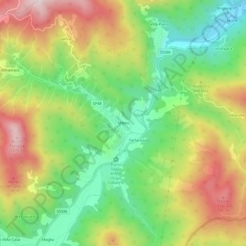
Name: Mileto topographic map, elevation, terrain.
Location: Mileto, Rezzoaglio, Genova, Liguria, 16048, Italia (44.47970 9.32614 44.51970 9.36614)
Average elevation: 3,130 ft
Minimum elevation: 2,326 ft
Maximum elevation: 4,160 ft
Make a donation
Gear up for your next adventure:
As an Amazon Associate, this site earns from qualifying purchases at no extra cost to you.
Other topographic maps
Click on a map to view its topography, its elevation and its terrain.
Lago delle Lame
Italia > Liguria > Genova > Rezzoaglio > Lago delle Lame
Il lago si trova a 1048 metri di altitudine sul livello del mare, si estende per circa 3600 m² ed è profondo al centro circa 8 m.
Average elevation: 3,606 ft