Geolocate

Gabriella topographic map

Click on the map to display elevation.

About this map

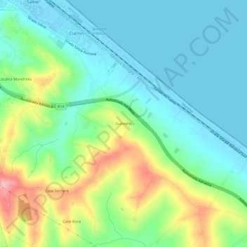
Name: Gabriella topographic map, elevation, terrain.

Location: Gabriella, Senigallia, Ancona, Marche, 60019, Italy (43.66721 13.23142 43.70721 13.27142)

Average elevation: 138 ft

Minimum elevation: -7 ft

Maximum elevation: 469 ft

Gear up for your next adventure:

🎒Waterproof Dry Bags - Keep your electronics and maps dry inside your pack
🧭Outdoor Navigation Book - Learn advanced navigation skills
🪶Camping Sleeping Pad - Comfortable sleeping pad for backpacking
🧭GPS Watch Accessories - Bands and chargers for GPS watches
🧥Men's Rain Shells - Premium waterproof and breathable jackets for mountain weather

As an Amazon Associate, this site earns from qualifying purchases at no extra cost to you.