
Eagle Nest WLS topographic map
Interactive map
Click on the map to display elevation.
About this map
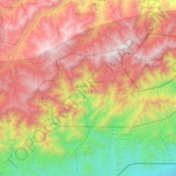
Name: Eagle Nest WLS topographic map, elevation, terrain.
Average elevation: 5,512 ft
Minimum elevation: 489 ft
Maximum elevation: 10,653 ft
Other topographic maps
Click on a map to view its topography, its elevation and its terrain.
Bhalukpong
India > Arunachal Pradesh > Bhalukpong EAC
Bhalukpong, Bhalukpong EAC, West Kameng District, Arunachal Pradesh, 790114, India
Average elevation: 797 ft
Sessa Orchid Sanctuary
India > Arunachal Pradesh > Bhalukpong EAC
Sessa Orchid Sanctuary, Doimara-Nichiphu, Bhalukpong EAC, West Kameng district, Arunachal Pradesh, 784147, India
Average elevation: 4,639 ft