
Thank you for supporting this site ❤️
Make a donation
Make a donation
Gear up for your next adventure:
As an Amazon Associate, this site earns from qualifying purchases at no extra cost to you.
L-Imġarr topographic map
Click on the map to display elevation.
Thank you for supporting this site ❤️
Make a donation
Make a donation
Gear up for your next adventure:
As an Amazon Associate, this site earns from qualifying purchases at no extra cost to you.
About this map
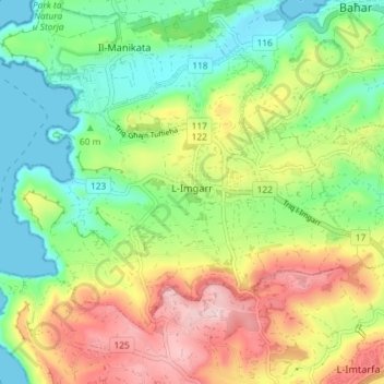
Name: L-Imġarr topographic map, elevation, terrain.
Location: L-Imġarr, Northern Region, MGR 1502, Malta (35.89676 14.33252 35.94068 14.40480)
Average elevation: 315 ft
Minimum elevation: 0 ft
Maximum elevation: 784 ft
Thank you for supporting this site ❤️
Make a donation
Make a donation
Gear up for your next adventure:
As an Amazon Associate, this site earns from qualifying purchases at no extra cost to you.