Geolocate

Callao topographic map

Click on the map to display elevation.

About this map

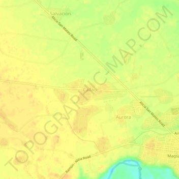
Name: Callao topographic map, elevation, terrain.

Location: Callao, Isabela, Cagayan Valley, 3306, Philippines (16.77226 121.65583 16.81226 121.69583)

Average elevation: 243 ft

Minimum elevation: 174 ft

Maximum elevation: 262 ft

Other topographic maps

Click on a map to view its topography, its elevation and its terrain.

Magat Dam

Philippines > Isabela

Average elevation: 577 ft

San Guillermo

Philippines > Isabela

Average elevation: 302 ft

Gear up for your next adventure:

🥾Hiking Shoes - Durable and comfortable shoes for trail hiking
🧭Hiking Compass - Precision compass for reliable navigation in the wilderness
📖Nature Tracking Books - Learn to track wildlife and terrain
🥾Men's Hiking Boots - Durable, waterproof footwear for rugged terrain and steep inclines
📷Action Camera - Capture your outdoor adventures in HD

As an Amazon Associate, this site earns from qualifying purchases at no extra cost to you.