Geolocate

Passaic topographic map

Click on the map to display elevation.

About this map

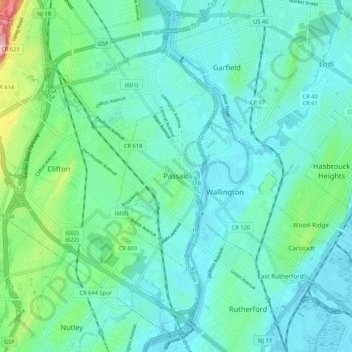
Name: Passaic topographic map, elevation, terrain.

Location: Passaic, Passaic County, New Jersey, 07055, United States (40.81677 -74.16848 40.89677 -74.08848)

Average elevation: 102 ft

Minimum elevation: 0 ft

Maximum elevation: 541 ft

Gear up for your next adventure:

📶Satellite Messenger - Communication device off‑grid
🔭Compact Binoculars - HD vision for scouting terrain and identifying distant landmarks
🪶Survival Guide Book - Expert advice for emergency preparedness
🌲Outdoor Survival Books - Best books on survival skills
🥇GPS Hiking Watch - Multi‑sport GPS watch with navigation and trail tracking

As an Amazon Associate, this site earns from qualifying purchases at no extra cost to you.