Geolocate

Bemidji topographic map

Click on the map to display elevation.

About this map

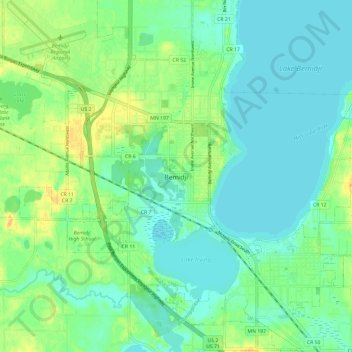
Name: Bemidji topographic map, elevation, terrain.

Location: Bemidji, Beltrami County, Minnesota, 56601, United States (47.43854 -94.93079 47.51854 -94.85079)

Average elevation: 1,365 ft

Minimum elevation: 1,332 ft

Maximum elevation: 1,424 ft

Beltrami County trails, hiking, mountain biking, running and outdoor activities

Gear up for your next adventure:

🧦Hiking Socks - Comfortable socks to prevent blisters on long hikes
🪶LED Camping Lantern - Bright lantern for camp lighting
🧢Outdoor Hiking Hat - Sun protection hat for outdoor explorers
🪵Folding Camp Saw - Compact saw for wood and campsite work
🖼️Topo Map Wall Art - Decorative topographic prints of famous peaks and regions

As an Amazon Associate, this site earns from qualifying purchases at no extra cost to you.