
Burgettstown topographic map
Click on the map to display elevation.
About this map
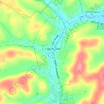
Name: Burgettstown topographic map, elevation, terrain.
Location: Burgettstown, Washington County, Pennsylvania, United States (40.37168 -80.39916 40.39055 -80.38548)
Average elevation: 1,086 ft
Minimum elevation: 951 ft
Maximum elevation: 1,250 ft
Washington County trails, hiking, mountain biking, running and outdoor activities
Other topographic maps
Click on a map to view its topography, its elevation and its terrain.
Cowden
United States > Pennsylvania > Washington County > Cecil Township > Cecil
Average elevation: 1,135 ft
Atlasburg
United States > Pennsylvania > Washington County > Smith Township
Average elevation: 1,165 ft
Malden Place
United States > Pennsylvania > Washington County > Centerville
Average elevation: 1,053 ft
Strabane
United States > Pennsylvania > Washington County > North Strabane Township
Average elevation: 1,079 ft
Millsboro
United States > Pennsylvania > Washington County > East Bethlehem Township
Average elevation: 1,010 ft
South Strabane
United States > Pennsylvania > Washington County > South Strabane Township
Average elevation: 1,237 ft
Vance
United States > Pennsylvania > Washington County > South Strabane Township
Average elevation: 1,217 ft
Independence
United States > Pennsylvania > Washington County > Independence Township
Average elevation: 1,171 ft
Avella
United States > Pennsylvania > Washington County > Independence Township
Average elevation: 1,083 ft
Langeloth
United States > Pennsylvania > Washington County > Smith Township
Average elevation: 1,155 ft
Lover
United States > Pennsylvania > Washington County > Fallowfield Township
Average elevation: 1,175 ft
Linden
United States > Pennsylvania > Washington County > North Strabane Township
Average elevation: 1,086 ft
Munntown
United States > Pennsylvania > Washington County > Nottingham Township
Average elevation: 1,152 ft
Chambers Mill
United States > Pennsylvania > Washington County > South Franklin Township
Average elevation: 1,201 ft
Enterprise
United States > Pennsylvania > Washington County > South Strabane Township
Average elevation: 1,096 ft
Blainsburg
United States > Pennsylvania > Washington County > West Brownsville
Average elevation: 978 ft
Victory Hills
United States > Pennsylvania > Washington County > Carroll Township
Average elevation: 1,004 ft
Mount Wheeler
United States > Pennsylvania > Washington County > North Franklin Township
Average elevation: 1,253 ft