
Leichlingen topographic map
Click on the map to display elevation.
About this map
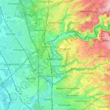
Name: Leichlingen topographic map, elevation, terrain.
Average elevation: 325 ft
Minimum elevation: 108 ft
Maximum elevation: 810 ft
Other topographic maps
Click on a map to view its topography, its elevation and its terrain.
Hau
Germany > North Rhine-Westphalia > Rheinisch-Bergischer Kreis > Kürten > Waldmühle
Average elevation: 751 ft
Bülsberg
Germany > North Rhine-Westphalia > Rheinisch-Bergischer Kreis > Odenthal > Altenberg
Average elevation: 538 ft
Ketzbergerhöhe
Germany > North Rhine-Westphalia > Rheinisch-Bergischer Kreis > Wermelskirchen > Dabringhausen
Average elevation: 712 ft
Hahnenberg
Germany > North Rhine-Westphalia > Rheinisch-Bergischer Kreis > Rösrath > Menzlingen
Average elevation: 404 ft