Geolocate

Mapita topographic map

Click on the map to display elevation.

About this map

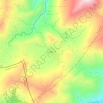
Name: Mapita topographic map, elevation, terrain.

Location: Mapita, Aguilar, Pangasinan, Ilocos Region, Philippines (15.80649 120.12645 15.84649 120.16645)

Average elevation: 1,572 ft

Minimum elevation: 604 ft

Maximum elevation: 2,536 ft

Gear up for your next adventure:

📚Navigation Handbooks - Master the art of reading topographic maps and using a compass
🔪Outdoor Multitools - Essential survival tools for gear repair and field use
📌Outdoor GPS Map App - Apps and devices for digital topographic navigation
🥇GPS Hiking Watch - Multi‑sport GPS watch with navigation and trail tracking
🧯Emergency Survival Kit - All‑in‑one survival essentials for the backcountry

As an Amazon Associate, this site earns from qualifying purchases at no extra cost to you.