
Avondale topographic map
Click on the map to display elevation.
About this map
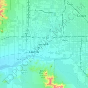
Name: Avondale topographic map, elevation, terrain.
Location: Avondale, Maricopa County, Arizona, 85323, United States (33.27560 -112.50960 33.59560 -112.18960)
Average elevation: 1,115 ft
Minimum elevation: 843 ft
Maximum elevation: 4,196 ft
Maricopa County trails, hiking, mountain biking, running and outdoor activities
Other topographic maps
Click on a map to view its topography, its elevation and its terrain.
Estrella Mountain Regional Park
United States > Arizona > Maricopa County > Avondale
Average elevation: 1,302 ft