
Donwood topographic map
Click on the map to display elevation.
About this map
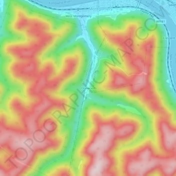
Name: Donwood topographic map, elevation, terrain.
Location: Donwood, Fayette County, West Virginia, 25316, United States (38.14233 -81.35206 38.18233 -81.31206)
Average elevation: 1,299 ft
Minimum elevation: 600 ft
Maximum elevation: 1,923 ft
Other topographic maps
Click on a map to view its topography, its elevation and its terrain.
New River Gorge National Park and Preserve
United States > West Virginia > Fayette County > Oak Hill
Average elevation: 2,277 ft
New River Gorge National Park
United States > West Virginia > Fayette County > Fayetteville
Average elevation: 2,149 ft
Glen Jean
United States > West Virginia > Fayette County > Glen Jean > White Oak Junction
Average elevation: 1,772 ft
New River Gorge National Park
United States > West Virginia > Fayette County > Fayetteville
Average elevation: 2,149 ft