Geolocate

Anjani topographic map

Click on the map to display elevation.

About this map

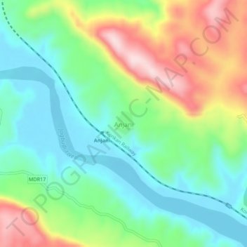
Name: Anjani topographic map, elevation, terrain.

Location: Anjani, Khed, Ratnagiri, Maharashtra, 415708, India (17.60251 73.38344 17.64251 73.42344)

Average elevation: 361 ft

Minimum elevation: -7 ft

Maximum elevation: 1,027 ft

Gear up for your next adventure:

GPS Sports Watch - GPS watch for running, hiking and training
🌡️Portable Weather Meter - Track weather conditions on the trail
🛌Ultralight Sleeping Bags - Compact down bags for cold nights in the wilderness
🦶Hiking Gaiters - Keep debris and water out of your boots
🌧️Backpack Rain Cover - Keep gear dry in wet weather

As an Amazon Associate, this site earns from qualifying purchases at no extra cost to you.