
Ostern topographic map
Interactive map
Click on the map to display elevation.
About this map
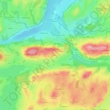
Name: Ostern topographic map, elevation, terrain.
Average elevation: 2,618 ft
Minimum elevation: 2,411 ft
Maximum elevation: 2,890 ft
Other topographic maps
Click on a map to view its topography, its elevation and its terrain.
Hochplatte
Deutschland > Bayern > Landkreis Ostallgäu > Halblech
Hochplatte, Halblech, Landkreis Ostallgäu, Bayern, Deutschland
Average elevation: 5,400 ft
Hirschwang
Deutschland > Bayern > Landkreis Ostallgäu > Halblech
Hirschwang, Halblech, Landkreis Ostallgäu, Bayern, Deutschland
Average elevation: 4,859 ft