Geolocate

Hochplatte topographic map

Click on the map to display elevation.

About this map

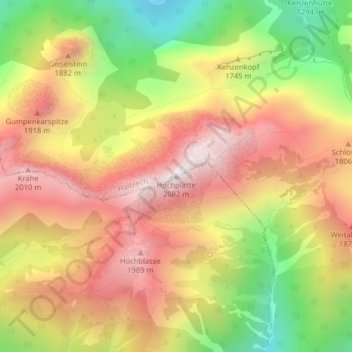
Name: Hochplatte topographic map, elevation, terrain.

Location: Hochplatte, Halblech, Landkreis Ostallgäu, Bayern, Deutschland (47.55222 10.84200 47.55232 10.84210)

Average elevation: 5,400 ft

Minimum elevation: 3,776 ft

Maximum elevation: 6,736 ft

Gear up for your next adventure:

🧤Tactile Hiking Gloves - Keep hands warm while operating GPS and smartphone screens
Solar GPS Watches - Advanced multisport watches with built-in topographic maps
🧣Merino Neck Gaiters - Multi-functional headwear for wind and sun protection
🏫Relief Map Kits - Hands-on tools for teaching landforms and elevation
📷Action Camera - Capture your outdoor adventures in HD

As an Amazon Associate, this site earns from qualifying purchases at no extra cost to you.