Geolocate

Raymond topographic map

Click on the map to display elevation.

About this map

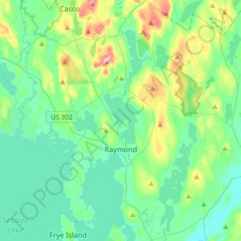
Name: Raymond topographic map, elevation, terrain.

Location: Raymond, Cumberland County, Maine, 04071, United States (43.83335 -70.54331 44.01281 -70.37450)

Average elevation: 374 ft

Minimum elevation: 200 ft

Maximum elevation: 1,010 ft

Cumberland County trails, hiking, mountain biking, running and outdoor activities

Other topographic maps

Click on a map to view its topography, its elevation and its terrain.

Brunswick

United States > Maine > Cumberland County

Average elevation: 85 ft

South Casco

United States > Maine > Cumberland County > Casco

Average elevation: 312 ft

North Bridgton

United States > Maine > Cumberland County > Bridgton

Average elevation: 400 ft

Oak Hill

United States > Maine > Cumberland County > Brunswick

Average elevation: 154 ft

USM Hedges

United States > Maine > Cumberland County > Gorham

Average elevation: 223 ft

Gear up for your next adventure:

🔌USB Car Charger - Car charger for on‑the‑go power needs
🧦Hiking Socks - Comfortable socks to prevent blisters on long hikes
🌄Hiking Binoculars - Compact binoculars for scenic views and trail spotting
🌲Outdoor Survival Books - Best books on survival skills
📌Outdoor GPS Map App - Apps and devices for digital topographic navigation

As an Amazon Associate, this site earns from qualifying purchases at no extra cost to you.