
Thank you for supporting this site ❤️
Make a donation
Make a donation
Gear up for your next adventure:
As an Amazon Associate, this site earns from qualifying purchases at no extra cost to you.
Laurelpamba topographic map
Click on the map to display elevation.
Thank you for supporting this site ❤️
Make a donation
Make a donation
Gear up for your next adventure:
As an Amazon Associate, this site earns from qualifying purchases at no extra cost to you.
About this map
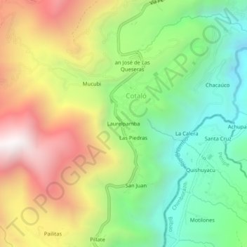
Name: Laurelpamba topographic map, elevation, terrain.
Location: Laurelpamba, Cotaló, Cotalo, Pelileo, Tungurahua, Ecuador (-1.45533 -78.53444 -1.41533 -78.49444)
Average elevation: 8,799 ft
Minimum elevation: 6,631 ft
Maximum elevation: 11,729 ft
Thank you for supporting this site ❤️
Make a donation
Make a donation
Gear up for your next adventure:
As an Amazon Associate, this site earns from qualifying purchases at no extra cost to you.