Geolocate

Sector 42 topographic map

Click on the map to display elevation.

About this map

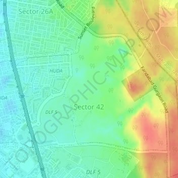
Name: Sector 42 topographic map, elevation, terrain.

Location: Sector 42, Gurgaon, Gurugram, Haryana, India (28.44923 77.09526 28.46795 77.12205)

Average elevation: 866 ft

Minimum elevation: 797 ft

Maximum elevation: 971 ft

Other topographic maps

Click on a map to view its topography, its elevation and its terrain.

Sohna

India > Haryana > Gurugram

Average elevation: 751 ft

Ghamroj

India > Haryana > Gurugram

Average elevation: 804 ft

Gear up for your next adventure:

🧣Merino Neck Gaiters - Multi-functional headwear for wind and sun protection
🧭Map Reading Tools - Tools and kits for map navigation
🪶Compact Camp Shovel - Folding shovel for campsite tasks
🪵Folding Camp Saw - Compact saw for wood and campsite work
🔭Stargazing Telescopes - Perfect for camping in low-light pollution areas shown on maps

As an Amazon Associate, this site earns from qualifying purchases at no extra cost to you.