
Make a donation
Gear up for your next adventure:
As an Amazon Associate, this site earns from qualifying purchases at no extra cost to you.
Aarau topographic map
Click on the map to display elevation.
Make a donation
Gear up for your next adventure:
As an Amazon Associate, this site earns from qualifying purchases at no extra cost to you.
Aarau
The old city of Aarau is situated on a rocky outcrop at a narrowing of the Aare river valley, at the southern foot of the Jura mountains. Newer districts of the city lie to the south and east of the outcrop, as well as higher up the mountain, and in the valley on both sides of the Aare. The neighboring municipalities are Küttigen to the north and Buchs to the east, Suhr to the south-east, Unterentfelden to the south, and Eppenberg-Wöschnau and Erlinsbach to the west. Aarau and the nearby neighboring municipalities have grown together and now form an interconnected agglomeration. The only exception is Unterentfelden whose settlements are divided from Aarau by the extensive forests of Gönhard and Zelgli. Approximately nine-tenths of the city is south of the Aare, and one tenth is to the north. It has an area, as of 2006, of 8.9 km2 (3.4 sq mi). Of this area, 6.3% is used for agricultural purposes, while 34% is forested. Of the rest of the land, 55.2% is settled (buildings or roads) and the remainder (4.5%) is non-productive (rivers or lakes). The lowest elevation, 365 meters (1,198 ft), is found at the banks of the Aar, and the highest elevation, at 471 meters (1,545 ft), is the Hungerberg on the border with Küttigen.
Make a donation
Gear up for your next adventure:
As an Amazon Associate, this site earns from qualifying purchases at no extra cost to you.
About this map
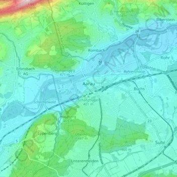
Name: Aarau topographic map, elevation, terrain.
Location: Aarau, Bezirk Aarau, Aargau, 5000, Switzerland (47.36972 8.02644 47.41235 8.11346)
Average elevation: 1,381 ft
Minimum elevation: 1,175 ft
Maximum elevation: 2,438 ft
Make a donation
Gear up for your next adventure:
As an Amazon Associate, this site earns from qualifying purchases at no extra cost to you.