
Make a donation
Gear up for your next adventure:
As an Amazon Associate, this site earns from qualifying purchases at no extra cost to you.
Schinnen topographic map
Click on the map to display elevation.
Make a donation
Gear up for your next adventure:
As an Amazon Associate, this site earns from qualifying purchases at no extra cost to you.
Schinnen
Schinnen ligt in het dal van de Geleenbeek, waar die samenkomt met het dal van de Kakkert. Het dorp bevindt zich tegen de helling van een uitloper van het Plateau van Doenrade en de kerk ligt op ongeveer 75 meter hoogte. Deze uitloper staat bekend als de Moutheuvel. Enkele wegen vormen hier de oude toegang vanuit het beekdal naar het plateau. Andere uitlopers rond Schinnen zijn de Krekelberg, de Putherberg en de Zandberg.
Make a donation
Gear up for your next adventure:
As an Amazon Associate, this site earns from qualifying purchases at no extra cost to you.
About this map
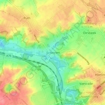
Name: Schinnen topographic map, elevation, terrain.
Location: Schinnen, Limburg, Nederland, 6365, Nederland (50.92248 5.86581 50.96248 5.90581)
Average elevation: 302 ft
Minimum elevation: 187 ft
Maximum elevation: 417 ft
Make a donation
Gear up for your next adventure:
As an Amazon Associate, this site earns from qualifying purchases at no extra cost to you.