
Make a donation
Gear up for your next adventure:
As an Amazon Associate, this site earns from qualifying purchases at no extra cost to you.
Mafadi topographic map
Click on the map to display elevation.
Make a donation
Gear up for your next adventure:
As an Amazon Associate, this site earns from qualifying purchases at no extra cost to you.
Mafadi
By the Himalayan definition of a mountain, being a summit with at least 7% topographic prominence relative to height, Mafadi is not in fact a mountain summit, but rather a subsidiary summit of Makheka in Lesotho. By this definition, Champagne Castle is the highest mountain summit in South Africa, although Mafadi is unquestionably the highest point in South Africa.
Make a donation
Gear up for your next adventure:
As an Amazon Associate, this site earns from qualifying purchases at no extra cost to you.
About this map
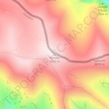
Name: Mafadi topographic map, elevation, terrain.
Location: Mafadi, Mokhotlong District, Lesotho (-29.20351 29.35847 -29.20341 29.35857)
Average elevation: 10,778 ft
Minimum elevation: 9,308 ft
Maximum elevation: 11,312 ft
Make a donation
Gear up for your next adventure:
As an Amazon Associate, this site earns from qualifying purchases at no extra cost to you.
Other topographic maps
Click on a map to view its topography, its elevation and its terrain.