
Thank you for supporting this site ❤️
Make a donation
Make a donation
Gear up for your next adventure:
As an Amazon Associate, this site earns from qualifying purchases at no extra cost to you.
Nanay topographic map
Click on the map to display elevation.
Thank you for supporting this site ❤️
Make a donation
Make a donation
Gear up for your next adventure:
As an Amazon Associate, this site earns from qualifying purchases at no extra cost to you.
About this map
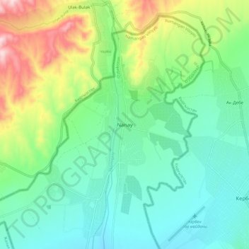
Name: Nanay topographic map, elevation, terrain.
Location: Nanay, Yangikurgan District, Namangan Region, Uzbekistan (41.47324 71.66280 41.55324 71.74280)
Average elevation: 4,560 ft
Minimum elevation: 4,173 ft
Maximum elevation: 5,528 ft
Thank you for supporting this site ❤️
Make a donation
Make a donation
Gear up for your next adventure:
As an Amazon Associate, this site earns from qualifying purchases at no extra cost to you.