
Thank you for supporting this site ❤️
Make a donation
Make a donation
Gear up for your next adventure:
As an Amazon Associate, this site earns from qualifying purchases at no extra cost to you.
Carignone topographic map
Click on the map to display elevation.
Thank you for supporting this site ❤️
Make a donation
Make a donation
Gear up for your next adventure:
As an Amazon Associate, this site earns from qualifying purchases at no extra cost to you.
About this map
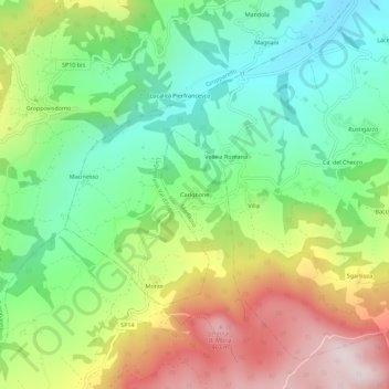
Name: Carignone topographic map, elevation, terrain.
Location: Carignone, Morfasso, Piacenza, Emilia-Romagna, Italia (44.76138 9.69729 44.80138 9.73729)
Average elevation: 1,821 ft
Minimum elevation: 1,020 ft
Maximum elevation: 3,058 ft
Thank you for supporting this site ❤️
Make a donation
Make a donation
Gear up for your next adventure:
As an Amazon Associate, this site earns from qualifying purchases at no extra cost to you.