Geolocate

Maldon topographic map

Click on the map to display elevation.

About this map

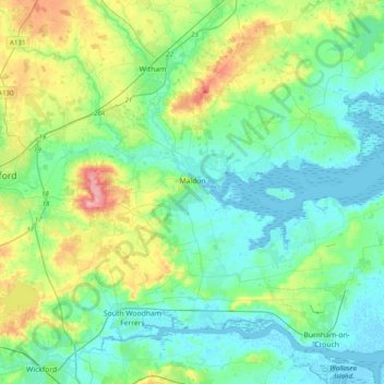
Name: Maldon topographic map, elevation, terrain.

Location: Maldon, Essex, England, United Kingdom (51.61844 0.58910 51.82912 0.98207)

Average elevation: 89 ft

Minimum elevation: -13 ft

Maximum elevation: 371 ft

Other topographic maps

Click on a map to view its topography, its elevation and its terrain.

Saffron Walden

United Kingdom > England > Essex > Uttlesford

Average elevation: 289 ft

Bulphan

United Kingdom > England > Essex

Average elevation: 33 ft

Winter Gardens

United Kingdom > England > Essex > Castle Point

Average elevation: 30 ft

Ramsden Heath

United Kingdom > England > Essex > Chelmsford

Average elevation: 190 ft

Wickford

United Kingdom > England > Essex

Average elevation: 89 ft

Little Walden

United Kingdom > England > Essex > Uttlesford

Average elevation: 308 ft

Hadleigh

United Kingdom > England > Essex > Castle Point

Average elevation: 95 ft

Stroud Green

United Kingdom > England > Essex > Rochford

Average elevation: 72 ft

Wivenhoe Woods

United Kingdom > England > Essex > Colchester > Wivenhoe > Rowhedge

Average elevation: 59 ft

Parkeston

United Kingdom > England > Essex > Parkeston

Average elevation: 16 ft

Dovercourt

United Kingdom > England > Essex > Tendring

Average elevation: 13 ft

Leigh Beck

United Kingdom > England > Essex > Castle Point

Average elevation: 3 ft

Mill End

United Kingdom > England > Essex > Uttlesford > Molehill Green

Average elevation: 331 ft

Gear up for your next adventure:

🎒Waterproof Dry Bags - Keep your electronics and maps dry inside your pack
🔭Telescopic Hiking Pole - Adjustable pole for hiking stability
🧣Hiking Neck Gaiter - Multi‑use neck protection for outdoor weather
🌧️Backpack Rain Cover - Keep gear dry in wet weather
🔌USB Car Charger - Car charger for on‑the‑go power needs

As an Amazon Associate, this site earns from qualifying purchases at no extra cost to you.