
Thank you for supporting this site ❤️
Make a donation
Make a donation
Gear up for your next adventure:
As an Amazon Associate, this site earns from qualifying purchases at no extra cost to you.
Stoodleigh topographic map
Click on the map to display elevation.
Thank you for supporting this site ❤️
Make a donation
Make a donation
Gear up for your next adventure:
As an Amazon Associate, this site earns from qualifying purchases at no extra cost to you.
About this map
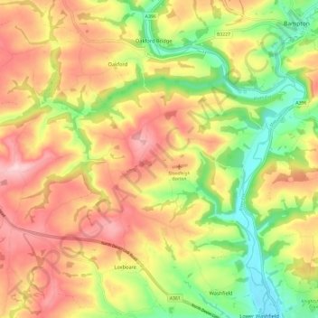
Name: Stoodleigh topographic map, elevation, terrain.
Location: Stoodleigh, Mid Devon, Devon, England, United Kingdom (50.94043 -3.60162 50.97745 -3.48344)
Average elevation: 614 ft
Minimum elevation: 217 ft
Maximum elevation: 991 ft
Thank you for supporting this site ❤️
Make a donation
Make a donation
Gear up for your next adventure:
As an Amazon Associate, this site earns from qualifying purchases at no extra cost to you.