Geolocate

Dug-Dug topographic map

Click on the map to display elevation.

About this map

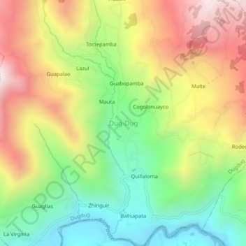
Name: Dug-Dug topographic map, elevation, terrain.

Location: Dug-Dug, Dugdug, Paute, Azuay, 010601, Ecuador (-2.76007 -78.74329 -2.72007 -78.70329)

Average elevation: 8,635 ft

Minimum elevation: 7,008 ft

Maximum elevation: 10,636 ft

Other topographic maps

Click on a map to view its topography, its elevation and its terrain.

El Cabo

Ecuador > Azuay > Paute

Average elevation: 8,225 ft

Chicán

Ecuador > Azuay > Paute

Average elevation: 8,642 ft

San Cristóbal

Ecuador > Azuay > Paute

Average elevation: 8,799 ft

Tomebamba

Ecuador > Azuay > Paute

Average elevation: 9,137 ft

Bulán

Ecuador > Azuay > Paute

Average elevation: 9,701 ft

Gear up for your next adventure:

🧺Microfiber Travel Towels - Compact and fast-drying towels for trail use
🪶Paracord Bracelet - Survival bracelet with built‑in tools
🏕️Family Camping Gear - Essentials for group camping trips
📷Action Cameras - Rugged cameras to document your journeys across rugged terrain
🛡️Bear Spray Outdoor - Protection in bear country hikes

As an Amazon Associate, this site earns from qualifying purchases at no extra cost to you.