
Make a donation
Gear up for your next adventure:
As an Amazon Associate, this site earns from qualifying purchases at no extra cost to you.
Victoria topographic map
Click on the map to display elevation.
Make a donation
Gear up for your next adventure:
As an Amazon Associate, this site earns from qualifying purchases at no extra cost to you.
About this map
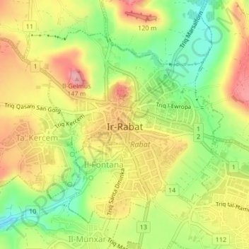
Name: Victoria topographic map, elevation, terrain.
Location: Victoria, Gozo Region, Malta (36.03283 14.22626 36.05333 14.25307)
Average elevation: 276 ft
Minimum elevation: 59 ft
Maximum elevation: 476 ft
Make a donation
Gear up for your next adventure:
As an Amazon Associate, this site earns from qualifying purchases at no extra cost to you.
Other topographic maps
Click on a map to view its topography, its elevation and its terrain.
Make a donation
Gear up for your next adventure:
As an Amazon Associate, this site earns from qualifying purchases at no extra cost to you.
Baħrija
Baħrija is one of the highest places in Malta, therefore the weather here is cooler than at lower elevations (it is also exposed to the cold northern winds coming over the sea). Most of the north of Malta is visible from this village, but the south west of Gozo (including Xlendi) is also visible, and on clear…
Average elevation: 381 ft
Make a donation
Gear up for your next adventure:
As an Amazon Associate, this site earns from qualifying purchases at no extra cost to you.
Make a donation
Gear up for your next adventure:
As an Amazon Associate, this site earns from qualifying purchases at no extra cost to you.