
Make a donation
Gear up for your next adventure:
As an Amazon Associate, this site earns from qualifying purchases at no extra cost to you.
Poiso topographic map
Click on the map to display elevation.
Make a donation
Gear up for your next adventure:
As an Amazon Associate, this site earns from qualifying purchases at no extra cost to you.
About this map
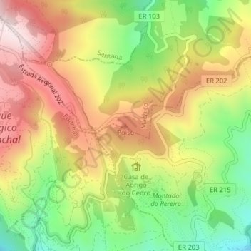
Name: Poiso topographic map, elevation, terrain.
Location: Poiso, Machico, Madeira, 9050-553, Portugal (32.71129 -16.89245 32.71139 -16.89235)
Average elevation: 4,252 ft
Minimum elevation: 3,412 ft
Maximum elevation: 5,075 ft
Make a donation
Gear up for your next adventure:
As an Amazon Associate, this site earns from qualifying purchases at no extra cost to you.
Other topographic maps
Click on a map to view its topography, its elevation and its terrain.
Porto da Cruz
A vila fica situada a 36KM do Funchal, em plena costa norte da ilha. Localiza-se na latitude 32.7667 (32°46') Norte e longitude 16.833 (16°50') Oeste, estando a uma altitude de 224 metros. Tem costa no Oceano Atlântico a norte e montanhas a sul.
Average elevation: 1,470 ft
Make a donation
Gear up for your next adventure:
As an Amazon Associate, this site earns from qualifying purchases at no extra cost to you.