Geolocate

Haarlem topographic map

Click on the map to display elevation.

About this map

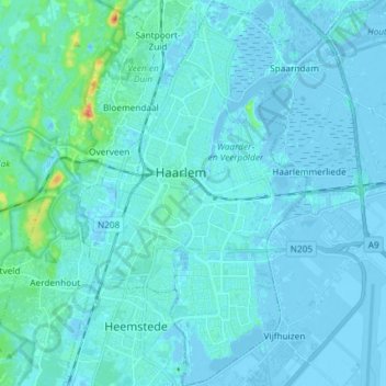
Name: Haarlem topographic map, elevation, terrain.

Location: Haarlem, North Holland, Netherlands (52.33891 4.59952 52.42857 4.68692)

Average elevation: 10 ft

Minimum elevation: -23 ft

Maximum elevation: 131 ft

Other topographic maps

Click on a map to view its topography, its elevation and its terrain.

Haarlem

Netherlands > North Holland > Haarlem

Average elevation: 0 ft

Gear up for your next adventure:

🎒Outdoor Daypacks - Lightweight backpacks designed for carrying maps and essential gear
🧭Hiking Compass - Precision compass for reliable navigation in the wilderness
🩳Quick‑Dry Hiking Shorts - Comfortable and quick‑dry shorts for summer hiking
🦟Ultrasonic Repellers - Create a bug-free zone at your camp or rest stop
🪶LED Camping Lantern - Bright lantern for camp lighting

As an Amazon Associate, this site earns from qualifying purchases at no extra cost to you.