
Soreng topographic map
Interactive map
Click on the map to display elevation.
About this map
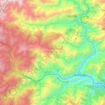
Name: Soreng topographic map, elevation, terrain.
Location: Soreng, Soreng District, Sikkim, India (27.11193 88.01203 27.27042 88.33039)
Average elevation: 5,315 ft
Minimum elevation: 801 ft
Maximum elevation: 12,306 ft
Other topographic maps
Click on a map to view its topography, its elevation and its terrain.
Lachung
India > Sikkim > Chungthang
Lachung, Chungthang, North Sikkim District, Sikkim, India
Average elevation: 11,867 ft
Katao
India > Sikkim > Chungthang
Katao, Chungthang, North Sikkim District, Sikkim, India
Average elevation: 14,780 ft
East District
India > Sikkim > East District
East District, East Sikkim District, Sikkim, India
Average elevation: 8,990 ft