
Soreng topographic map
Click on the map to display elevation.
About this map
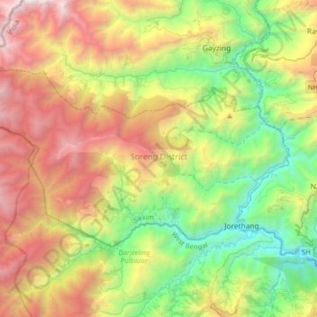
Name: Soreng topographic map, elevation, terrain.
Location: Soreng, Soreng District, Sikkim, India (27.11193 88.01203 27.27042 88.33039)
Average elevation: 5,315 ft
Minimum elevation: 801 ft
Maximum elevation: 12,306 ft
Other topographic maps
Click on a map to view its topography, its elevation and its terrain.
Lachung
India > Sikkim > Chungthang
Lachung is a town and hill station in northeast Sikkim, India. It is located in the North Sikkim district near the border with Tibet. Lachung is at an elevation of about 9,600 feet (2,900 m) and at the confluence of the Lachen and Lachung Rivers, both tributaries of the River Teesta. The word Lachung means…
Average elevation: 11,867 ft
Gangtok
Gangtok (Nepali: [gantok] gāntok, Sikkimese: [ɡaŋt̪ʰòk]) is the capital and the most populous city of the Indian state of Sikkim. The seat of eponymous district, Gangtok is in the eastern Himalayan range, at an elevation of 1,650 m (5,410 ft). The city's population of 100,000 consists of the three…
Average elevation: 6,270 ft
Nathu La
Nathu La is a mountain pass on the Dongkya Range that separates Sikkim and the Chumbi Valley at an elevation of 14,250 feet (4,340 m). The pass is 52–54 kilometres (32–34 mi) east of Gangtok, the capital of Sikkim, and 35 kilometres (22 mi) from Yatung Shasima, the headquarters of the Yadong County (or the…
Average elevation: 13,911 ft