
Make a donation
Gear up for your next adventure:
As an Amazon Associate, this site earns from qualifying purchases at no extra cost to you.
Residencial Sarandi topographic map
Click on the map to display elevation.
Make a donation
Gear up for your next adventure:
As an Amazon Associate, this site earns from qualifying purchases at no extra cost to you.
About this map
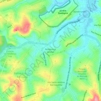
Name: Residencial Sarandi topographic map, elevation, terrain.
Average elevation: 2,766 ft
Minimum elevation: 2,635 ft
Maximum elevation: 3,012 ft
Make a donation
Gear up for your next adventure:
As an Amazon Associate, this site earns from qualifying purchases at no extra cost to you.
Other topographic maps
Click on a map to view its topography, its elevation and its terrain.
Campus UFMG
Brasil > Minas Gerais > Região Metropolitana de Belo Horizonte > Belo Horizonte
Average elevation: 2,740 ft
Savassi
Brasil > Minas Gerais > Região Metropolitana de Belo Horizonte > Belo Horizonte
Average elevation: 2,969 ft
Sagrada Família
Brasil > Minas Gerais > Região Metropolitana de Belo Horizonte > Belo Horizonte
Average elevation: 2,782 ft
Lagoa da Pampulha
Brasil > Minas Gerais > Região Metropolitana de Belo Horizonte > Belo Horizonte
Average elevation: 2,674 ft
Make a donation
Gear up for your next adventure:
As an Amazon Associate, this site earns from qualifying purchases at no extra cost to you.
Padre Eustáquio
Brasil > Minas Gerais > Região Metropolitana de Belo Horizonte > Belo Horizonte
Average elevation: 2,923 ft
Serra do Curral
Brasil > Minas Gerais > Região Metropolitana de Belo Horizonte > Belo Horizonte
Average elevation: 3,845 ft
Engenho Nogueira
Brasil > Minas Gerais > Região Metropolitana de Belo Horizonte > Belo Horizonte
Average elevation: 2,848 ft
Bonsucesso
Brasil > Minas Gerais > Região Metropolitana de Belo Horizonte > Belo Horizonte
Average elevation: 3,356 ft
Make a donation
Gear up for your next adventure:
As an Amazon Associate, this site earns from qualifying purchases at no extra cost to you.
São Bento
Brasil > Minas Gerais > Região Metropolitana de Belo Horizonte > Belo Horizonte
Average elevation: 3,219 ft
Jardim Alvorada
Brasil > Minas Gerais > Região Metropolitana de Belo Horizonte > Belo Horizonte
Average elevation: 2,904 ft
Córrego do Nado
Brasil > Minas Gerais > Região Metropolitana de Belo Horizonte > Belo Horizonte
Average elevation: 2,549 ft
Aparecida
Brasil > Minas Gerais > Região Metropolitana de Belo Horizonte > Belo Horizonte
Average elevation: 2,828 ft
Make a donation
Gear up for your next adventure:
As an Amazon Associate, this site earns from qualifying purchases at no extra cost to you.
Praça da Bandeira
Brasil > Minas Gerais > Região Metropolitana de Belo Horizonte > Belo Horizonte
Average elevation: 3,412 ft
Pampulha
Brasil > Minas Gerais > Região Metropolitana de Belo Horizonte > Belo Horizonte
Average elevation: 2,743 ft
Paquetá
Brasil > Minas Gerais > Região Metropolitana de Belo Horizonte > Belo Horizonte > Itamarati
Average elevation: 2,789 ft
Parque das Mangabeiras
Brasil > Minas Gerais > Região Metropolitana de Belo Horizonte > Belo Horizonte
Average elevation: 3,622 ft
Make a donation
Gear up for your next adventure:
As an Amazon Associate, this site earns from qualifying purchases at no extra cost to you.
Boa Viagem
Brasil > Minas Gerais > Região Metropolitana de Belo Horizonte > Belo Horizonte
Average elevation: 2,894 ft
Belvedere
Brasil > Minas Gerais > Região Metropolitana de Belo Horizonte > Belo Horizonte
Average elevation: 3,533 ft
Comiteco
Brasil > Minas Gerais > Região Metropolitana de Belo Horizonte > Belo Horizonte
Average elevation: 3,547 ft
Córrego do Zoológico
Brasil > Minas Gerais > Região Metropolitana de Belo Horizonte > Belo Horizonte
Average elevation: 2,982 ft
Make a donation
Gear up for your next adventure:
As an Amazon Associate, this site earns from qualifying purchases at no extra cost to you.
Mangabeiras
Brasil > Minas Gerais > Região Metropolitana de Belo Horizonte > Belo Horizonte
Average elevation: 3,494 ft
Alto dos Pinheiros
Brasil > Minas Gerais > Região Metropolitana de Belo Horizonte > Belo Horizonte
Average elevation: 2,999 ft
Venda Nova
Brasil > Minas Gerais > Região Metropolitana de Belo Horizonte > Belo Horizonte
Average elevation: 2,638 ft
Parque Mata das Borboletas
Brasil > Minas Gerais > Região Metropolitana de Belo Horizonte > Belo Horizonte
Average elevation: 3,399 ft
Make a donation
Gear up for your next adventure:
As an Amazon Associate, this site earns from qualifying purchases at no extra cost to you.
Lagoa do Nado
Brasil > Minas Gerais > Região Metropolitana de Belo Horizonte > Belo Horizonte
Average elevation: 2,602 ft
São Tomaz
Brasil > Minas Gerais > Região Metropolitana de Belo Horizonte > Belo Horizonte
Average elevation: 2,615 ft
Barro Preto
Brasil > Minas Gerais > Região Metropolitana de Belo Horizonte > Belo Horizonte
Average elevation: 2,881 ft
Vila Antena Montanhês
Brasil > Minas Gerais > Região Metropolitana de Belo Horizonte > Belo Horizonte
Average elevation: 2,910 ft
Make a donation
Gear up for your next adventure:
As an Amazon Associate, this site earns from qualifying purchases at no extra cost to you.
Praça Nova York
Brasil > Minas Gerais > Região Metropolitana de Belo Horizonte > Belo Horizonte
Average elevation: 3,304 ft
Olaria
Brasil > Minas Gerais > Região Metropolitana de Belo Horizonte > Belo Horizonte
Average elevation: 3,199 ft
Barreiro
Brasil > Minas Gerais > Região Metropolitana de Belo Horizonte > Belo Horizonte
Average elevation: 3,530 ft
Floramar
Brasil > Minas Gerais > Região Metropolitana de Belo Horizonte > Belo Horizonte
Average elevation: 2,595 ft
Make a donation
Gear up for your next adventure:
As an Amazon Associate, this site earns from qualifying purchases at no extra cost to you.
Carmo
Brasil > Minas Gerais > Região Metropolitana de Belo Horizonte > Belo Horizonte
Average elevation: 3,104 ft
Vila Acaba Mundo
Brasil > Minas Gerais > Região Metropolitana de Belo Horizonte > Belo Horizonte
Average elevation: 3,583 ft
Buritis
Brasil > Minas Gerais > Região Metropolitana de Belo Horizonte > Belo Horizonte
Average elevation: 3,343 ft
Sion
Brasil > Minas Gerais > Região Metropolitana de Belo Horizonte > Belo Horizonte
Average elevation: 3,320 ft
Make a donation
Gear up for your next adventure:
As an Amazon Associate, this site earns from qualifying purchases at no extra cost to you.
Santa Tereza
Brasil > Minas Gerais > Região Metropolitana de Belo Horizonte > Belo Horizonte
Average elevation: 2,785 ft
Horto Florestal
Brasil > Minas Gerais > Região Metropolitana de Belo Horizonte > Belo Horizonte
Average elevation: 2,766 ft
Olhos d'Água
Brasil > Minas Gerais > Região Metropolitana de Belo Horizonte > Belo Horizonte
Average elevation: 3,573 ft
Nova Cintra
Brasil > Minas Gerais > Região Metropolitana de Belo Horizonte > Belo Horizonte
Average elevation: 2,963 ft
Make a donation
Gear up for your next adventure:
As an Amazon Associate, this site earns from qualifying purchases at no extra cost to you.
Regional Noroeste
Brasil > Minas Gerais > Região Metropolitana de Belo Horizonte > Belo Horizonte
Average elevation: 2,864 ft
Céu Azul
Brasil > Minas Gerais > Região Metropolitana de Belo Horizonte > Belo Horizonte
Average elevation: 2,707 ft
Visconde do Rio Branco
Brasil > Minas Gerais > Região Metropolitana de Belo Horizonte > Belo Horizonte
Average elevation: 2,648 ft
Córrego Acaba Mundo
Brasil > Minas Gerais > Região Metropolitana de Belo Horizonte > Belo Horizonte
Average elevation: 2,864 ft
Make a donation
Gear up for your next adventure:
As an Amazon Associate, this site earns from qualifying purchases at no extra cost to you.
Parque Municipal Américo Renê Giannetti
Brasil > Minas Gerais > Região Metropolitana de Belo Horizonte > Belo Horizonte
Average elevation: 2,854 ft
Funcionários
Brasil > Minas Gerais > Região Metropolitana de Belo Horizonte > Belo Horizonte
Average elevation: 2,972 ft
Vila Santana do Cafezal
Brasil > Minas Gerais > Região Metropolitana de Belo Horizonte > Belo Horizonte
Average elevation: 3,196 ft
Renascença
Brasil > Minas Gerais > Região Metropolitana de Belo Horizonte > Belo Horizonte
Average elevation: 2,759 ft
Make a donation
Gear up for your next adventure:
As an Amazon Associate, this site earns from qualifying purchases at no extra cost to you.
Praça da Estação
Brasil > Minas Gerais > Região Metropolitana de Belo Horizonte > Belo Horizonte
Average elevation: 2,831 ft
Gameleira
Brasil > Minas Gerais > Região Metropolitana de Belo Horizonte > Belo Horizonte
Average elevation: 2,927 ft
Nova Suíça
Brasil > Minas Gerais > Região Metropolitana de Belo Horizonte > Belo Horizonte
Average elevation: 2,920 ft
Bairro Novo das Indústrias
Brasil > Minas Gerais > Região Metropolitana de Belo Horizonte > Belo Horizonte
Average elevation: 3,130 ft
Make a donation
Gear up for your next adventure:
As an Amazon Associate, this site earns from qualifying purchases at no extra cost to you.
Praça do Sol
Brasil > Minas Gerais > Região Metropolitana de Belo Horizonte > Belo Horizonte
Average elevation: 3,478 ft
Praça do Bairro Jaqueline
Brasil > Minas Gerais > Região Metropolitana de Belo Horizonte > Belo Horizonte
Average elevation: 2,592 ft
Tirol
Brasil > Minas Gerais > Região Metropolitana de Belo Horizonte > Belo Horizonte
Average elevation: 3,176 ft
Vila Clóris
Brasil > Minas Gerais > Região Metropolitana de Belo Horizonte > Belo Horizonte
Average elevation: 2,546 ft
Make a donation
Gear up for your next adventure:
As an Amazon Associate, this site earns from qualifying purchases at no extra cost to you.
Praça João Pessoa
Brasil > Minas Gerais > Região Metropolitana de Belo Horizonte > Belo Horizonte
Average elevation: 2,910 ft
Santa Inês
Brasil > Minas Gerais > Região Metropolitana de Belo Horizonte > Belo Horizonte
Average elevation: 2,759 ft
Grajaú
Brasil > Minas Gerais > Região Metropolitana de Belo Horizonte > Belo Horizonte
Average elevation: 3,018 ft
Praça da Liberdade
Brasil > Minas Gerais > Região Metropolitana de Belo Horizonte > Belo Horizonte
Average elevation: 2,923 ft
Make a donation
Gear up for your next adventure:
As an Amazon Associate, this site earns from qualifying purchases at no extra cost to you.
Itatiaia
Brasil > Minas Gerais > Região Metropolitana de Belo Horizonte > Belo Horizonte
Average elevation: 2,740 ft
Araguaia
Brasil > Minas Gerais > Região Metropolitana de Belo Horizonte > Belo Horizonte
Average elevation: 3,245 ft
Juliana
Brasil > Minas Gerais > Região Metropolitana de Belo Horizonte > Belo Horizonte
Average elevation: 2,536 ft
Granja Werneck
Brasil > Minas Gerais > Região Metropolitana de Belo Horizonte > Belo Horizonte
Average elevation: 2,539 ft
Make a donation
Gear up for your next adventure:
As an Amazon Associate, this site earns from qualifying purchases at no extra cost to you.
Trevo
Brasil > Minas Gerais > Região Metropolitana de Belo Horizonte > Belo Horizonte
Average elevation: 2,766 ft
Planalto
Brasil > Minas Gerais > Região Metropolitana de Belo Horizonte > Belo Horizonte
Average elevation: 2,582 ft
Santa Mônica
Brasil > Minas Gerais > Região Metropolitana de Belo Horizonte > Belo Horizonte
Average elevation: 2,621 ft
Palmares
Brasil > Minas Gerais > Região Metropolitana de Belo Horizonte > Belo Horizonte
Average elevation: 2,657 ft
Make a donation
Gear up for your next adventure:
As an Amazon Associate, this site earns from qualifying purchases at no extra cost to you.
Vila Nova Paraíso
Brasil > Minas Gerais > Região Metropolitana de Belo Horizonte > Belo Horizonte
Average elevation: 3,179 ft
Estação Ecológica Estadual do Cercadinho
Brasil > Minas Gerais > Região Metropolitana de Belo Horizonte > Belo Horizonte
Average elevation: 3,638 ft
Luxemburgo
Brasil > Minas Gerais > Região Metropolitana de Belo Horizonte > Belo Horizonte
Average elevation: 3,081 ft
Vila Paris
Brasil > Minas Gerais > Região Metropolitana de Belo Horizonte > Belo Horizonte
Average elevation: 3,159 ft
Make a donation
Gear up for your next adventure:
As an Amazon Associate, this site earns from qualifying purchases at no extra cost to you.
Ribeirão do Onça
Brasil > Minas Gerais > Região Metropolitana de Belo Horizonte > Belo Horizonte
Average elevation: 2,464 ft
Cidade Jardim
Brasil > Minas Gerais > Região Metropolitana de Belo Horizonte > Belo Horizonte
Average elevation: 3,015 ft
Pilar
Brasil > Minas Gerais > Região Metropolitana de Belo Horizonte > Belo Horizonte
Average elevation: 3,740 ft
Betânia
Brasil > Minas Gerais > Região Metropolitana de Belo Horizonte > Belo Horizonte
Average elevation: 2,992 ft
Make a donation
Gear up for your next adventure:
As an Amazon Associate, this site earns from qualifying purchases at no extra cost to you.
Paraíso
Brasil > Minas Gerais > Região Metropolitana de Belo Horizonte > Belo Horizonte
Average elevation: 2,897 ft
Jardim dos Comerciários
Brasil > Minas Gerais > Região Metropolitana de Belo Horizonte > Belo Horizonte
Average elevation: 2,703 ft
Califórnia
Brasil > Minas Gerais > Região Metropolitana de Belo Horizonte > Belo Horizonte
Average elevation: 2,986 ft
Baleia
Brasil > Minas Gerais > Região Metropolitana de Belo Horizonte > Belo Horizonte
Average elevation: 3,422 ft
Make a donation
Gear up for your next adventure:
As an Amazon Associate, this site earns from qualifying purchases at no extra cost to you.
Conjunto Celso Machado
Brasil > Minas Gerais > Região Metropolitana de Belo Horizonte > Belo Horizonte
Average elevation: 2,772 ft
Cidade Nova
Brasil > Minas Gerais > Região Metropolitana de Belo Horizonte > Belo Horizonte
Average elevation: 2,743 ft
Horto
Brasil > Minas Gerais > Região Metropolitana de Belo Horizonte > Belo Horizonte
Average elevation: 2,772 ft
Alto dos Caiçaras
Brasil > Minas Gerais > Região Metropolitana de Belo Horizonte > Belo Horizonte
Average elevation: 2,920 ft
Make a donation
Gear up for your next adventure:
As an Amazon Associate, this site earns from qualifying purchases at no extra cost to you.
Regional Leste
Brasil > Minas Gerais > Região Metropolitana de Belo Horizonte > Belo Horizonte
Average elevation: 2,923 ft
Conjunto Paulo VI
Brasil > Minas Gerais > Região Metropolitana de Belo Horizonte > Belo Horizonte
Average elevation: 2,425 ft
Ribeirão Arrudas
Brasil > Minas Gerais > Região Metropolitana de Belo Horizonte > Belo Horizonte
Average elevation: 2,838 ft
São Luiz
Brasil > Minas Gerais > Região Metropolitana de Belo Horizonte > Belo Horizonte
Average elevation: 2,680 ft
Make a donation
Gear up for your next adventure:
As an Amazon Associate, this site earns from qualifying purchases at no extra cost to you.
Solimões
Brasil > Minas Gerais > Região Metropolitana de Belo Horizonte > Belo Horizonte
Average elevation: 2,526 ft
Parque Alexander Brandt
Brasil > Minas Gerais > Região Metropolitana de Belo Horizonte > Belo Horizonte
Average elevation: 2,628 ft
Parque Municipal Ursulina de Andrade Mello
Brasil > Minas Gerais > Região Metropolitana de Belo Horizonte > Belo Horizonte
Average elevation: 2,789 ft
Regional Nordeste
Brasil > Minas Gerais > Região Metropolitana de Belo Horizonte > Belo Horizonte
Average elevation: 2,592 ft
Make a donation
Gear up for your next adventure:
As an Amazon Associate, this site earns from qualifying purchases at no extra cost to you.
Centro
Brasil > Minas Gerais > Região Metropolitana de Belo Horizonte > Belo Horizonte
Average elevation: 2,835 ft
Córrego do Zoológico
Brasil > Minas Gerais > Região Metropolitana de Belo Horizonte > Belo Horizonte
Average elevation: 2,940 ft
Parque Ecológico Padre Alfredo Sabeta
Brasil > Minas Gerais > Região Metropolitana de Belo Horizonte > Belo Horizonte
Average elevation: 3,150 ft
Nova Gameleira
Brasil > Minas Gerais > Região Metropolitana de Belo Horizonte > Belo Horizonte
Average elevation: 2,953 ft
Make a donation
Gear up for your next adventure:
As an Amazon Associate, this site earns from qualifying purchases at no extra cost to you.
Jardim América
Brasil > Minas Gerais > Região Metropolitana de Belo Horizonte > Belo Horizonte
Average elevation: 3,022 ft
Xodô-Marize
Brasil > Minas Gerais > Região Metropolitana de Belo Horizonte > Belo Horizonte
Average elevation: 2,530 ft
Praça José Jeremias de Mesquita
Brasil > Minas Gerais > Região Metropolitana de Belo Horizonte > Belo Horizonte
Average elevation: 2,687 ft
Praca Quatro Mil Cento E Quarenta E Um
Brasil > Minas Gerais > Região Metropolitana de Belo Horizonte > Belo Horizonte
Average elevation: 2,969 ft
Make a donation
Gear up for your next adventure:
As an Amazon Associate, this site earns from qualifying purchases at no extra cost to you.