
Make a donation
Gear up for your next adventure:
As an Amazon Associate, this site earns from qualifying purchases at no extra cost to you.
La Huasteca topographic map
Click on the map to display elevation.
Make a donation
Gear up for your next adventure:
As an Amazon Associate, this site earns from qualifying purchases at no extra cost to you.
About this map
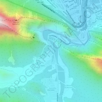
Name: La Huasteca topographic map, elevation, terrain.
Location: La Huasteca, Santa Catarina, Nuevo León, México (25.64515 -100.46039 25.64774 -100.45914)
Average elevation: 2,684 ft
Minimum elevation: 2,178 ft
Maximum elevation: 4,764 ft
Make a donation
Gear up for your next adventure:
As an Amazon Associate, this site earns from qualifying purchases at no extra cost to you.
Other topographic maps
Click on a map to view its topography, its elevation and its terrain.
Sierra Madre Oriental
México > Nuevo León > Galeana
La cordillera tiene una topografía accidentada en la que los valles, los cañones y los barrancos son frecuentes. El pico más alto es el Cerro El Potosí con 3713 metros sobre el nivel del mar.
Average elevation: 10,079 ft