
Make a donation
Gear up for your next adventure:
As an Amazon Associate, this site earns from qualifying purchases at no extra cost to you.
Aïn Draham topographic map
Click on the map to display elevation.
Make a donation
Gear up for your next adventure:
As an Amazon Associate, this site earns from qualifying purchases at no extra cost to you.
Aïn Draham
The city is the capital of a delegation of 40,372 inhabitants. The city itself has an estimated population of 10,843 inhabitants (according to the census of 2004). It is located at an altitude of 800 meters on the slopes of the Djebel Bir (1014 m), one of the Kroumirie mountains. The city is located in one of the most humid areas of Tunisia and holds the record for the highest average rainfall at 1534 mm per year. Rainfalls are one of the major factors influencing landslides, often occurring in this area.
Make a donation
Gear up for your next adventure:
As an Amazon Associate, this site earns from qualifying purchases at no extra cost to you.
About this map
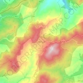
Name: Aïn Draham topographic map, elevation, terrain.
Average elevation: 1,883 ft
Minimum elevation: 551 ft
Maximum elevation: 3,317 ft
Make a donation
Gear up for your next adventure:
As an Amazon Associate, this site earns from qualifying purchases at no extra cost to you.