
Make a donation
Gear up for your next adventure:
As an Amazon Associate, this site earns from qualifying purchases at no extra cost to you.
Basedow topographic map
Click on the map to display elevation.
Make a donation
Gear up for your next adventure:
As an Amazon Associate, this site earns from qualifying purchases at no extra cost to you.
Basedow
Im Südwesten des Gemeindegebiets hebt sich das Relief mit dem Basedower Berg auf die Höhenlage von bis zu 47,1 m über Normalhöhennull.
Make a donation
Gear up for your next adventure:
As an Amazon Associate, this site earns from qualifying purchases at no extra cost to you.
About this map
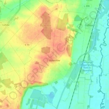
Name: Basedow topographic map, elevation, terrain.
Average elevation: 82 ft
Minimum elevation: 13 ft
Maximum elevation: 167 ft
Make a donation
Gear up for your next adventure:
As an Amazon Associate, this site earns from qualifying purchases at no extra cost to you.
Other topographic maps
Click on a map to view its topography, its elevation and its terrain.
Rothenhusen
Deutschland > Schleswig-Holstein > Kreis Herzogtum Lauenburg > Groß Sarau
Average elevation: 66 ft
Drüsen
Deutschland > Schleswig-Holstein > Kreis Herzogtum Lauenburg > Lehmrade
Average elevation: 131 ft
Make a donation
Gear up for your next adventure:
As an Amazon Associate, this site earns from qualifying purchases at no extra cost to you.
Dalbekschlucht
Deutschland > Schleswig-Holstein > Kreis Herzogtum Lauenburg > Börnsen
Average elevation: 131 ft