
Thank you for supporting this site ❤️
Make a donation
Make a donation
Gear up for your next adventure:
As an Amazon Associate, this site earns from qualifying purchases at no extra cost to you.
Glasberg topographic map
Click on the map to display elevation.
Thank you for supporting this site ❤️
Make a donation
Make a donation
Gear up for your next adventure:
As an Amazon Associate, this site earns from qualifying purchases at no extra cost to you.
About this map
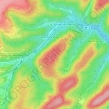
Name: Glasberg topographic map, elevation, terrain.
Location: Glasberg, Pirmasens, Rheinland-Pfalz, 66976, Deutschland (49.20711 7.64567 49.20721 7.64577)
Average elevation: 1,181 ft
Minimum elevation: 951 ft
Maximum elevation: 1,440 ft
Thank you for supporting this site ❤️
Make a donation
Make a donation
Gear up for your next adventure:
As an Amazon Associate, this site earns from qualifying purchases at no extra cost to you.