
Make a donation
Gear up for your next adventure:
As an Amazon Associate, this site earns from qualifying purchases at no extra cost to you.
Kirchlispitzen topographic map
Click on the map to display elevation.
Make a donation
Gear up for your next adventure:
As an Amazon Associate, this site earns from qualifying purchases at no extra cost to you.
Kirchlispitzen
Ganz im Westen der Kette liegt die Erste Kirchlispitze, im Osten schließlich erhebt sich die Siebte Kirchlispitze, die niedrigste, mit 2350 Metern Höhe. Die Südwände der Bergkette, die bis zu 500 Meter tief auf Graubündner Gebiet abstürzen, bieten für Kletterer lohnende Ziele in den oberen Schwierigkeitsgraden bis hin zur Extremkletterei im Schwierigkeitsgrad UIAA IX-. Diese Routen wurden seit den 1980er Jahren erstmals begangen. Die Erstbesteigung der Dritten Kirchlispitze erfolgte, laut Literatur, hingegen am 14. August 1891 im Alleingang durch einen A. Ludwig vom Schweizer Alpen-Club.
Make a donation
Gear up for your next adventure:
As an Amazon Associate, this site earns from qualifying purchases at no extra cost to you.
About this map
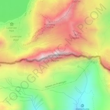
Name: Kirchlispitzen topographic map, elevation, terrain.
Average elevation: 6,900 ft
Minimum elevation: 5,502 ft
Maximum elevation: 8,291 ft
Make a donation
Gear up for your next adventure:
As an Amazon Associate, this site earns from qualifying purchases at no extra cost to you.