
Thank you for supporting this site ❤️
Make a donation
Make a donation
Gear up for your next adventure:
As an Amazon Associate, this site earns from qualifying purchases at no extra cost to you.
Wutzelskühn topographic map
Click on the map to display elevation.
Thank you for supporting this site ❤️
Make a donation
Make a donation
Gear up for your next adventure:
As an Amazon Associate, this site earns from qualifying purchases at no extra cost to you.
Wutzelskühn
Das Dorf Wutzelskühn liegt circa fünf Kilometer südwestlich von Neunburg vorm Wald und einen Kilometer vom Ortsteil Penting entfernt auf einem Höhenzug über dem Schwarzachtal.
Thank you for supporting this site ❤️
Make a donation
Make a donation
Gear up for your next adventure:
As an Amazon Associate, this site earns from qualifying purchases at no extra cost to you.
About this map
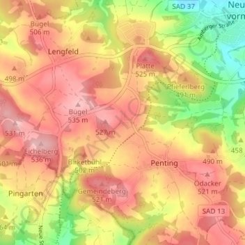
Name: Wutzelskühn topographic map, elevation, terrain.
Average elevation: 1,555 ft
Minimum elevation: 1,240 ft
Maximum elevation: 1,765 ft
Thank you for supporting this site ❤️
Make a donation
Make a donation
Gear up for your next adventure:
As an Amazon Associate, this site earns from qualifying purchases at no extra cost to you.