Geolocate

Chideock topographic map

Click on the map to display elevation.

About this map

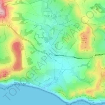
Name: Chideock topographic map, elevation, terrain.

Location: Chideock, Dorset, England, United Kingdom (50.71718 -2.84569 50.74836 -2.79859)

Average elevation: 223 ft

Minimum elevation: 0 ft

Maximum elevation: 676 ft

Gear up for your next adventure:

🚁Photography Drones - Capture stunning aerial views of landforms and topography
🛰️Satellite Messengers - Emergency SOS and two-way messaging for off-grid adventures
🧭Map Reading Tools - Tools and kits for map navigation
GPS Sports Watch - GPS watch for running, hiking and training
🪓Survival Multi‑Tool - Versatile tool for camp and trail tasks

As an Amazon Associate, this site earns from qualifying purchases at no extra cost to you.