Geolocate

Maco topographic map

Click on the map to display elevation.

About this map

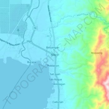
Name: Maco topographic map, elevation, terrain.

Location: Maco, Davao de Oro, Davao Region, 8806, Philippines (7.32880 125.81566 7.40880 125.89566)

Average elevation: 276 ft

Minimum elevation: -7 ft

Maximum elevation: 2,119 ft

Other topographic maps

Click on a map to view its topography, its elevation and its terrain.

Laak

Philippines > Davao de Oro

Average elevation: 554 ft

New Bataan

Philippines > Davao de Oro

Average elevation: 2,457 ft

Gear up for your next adventure:

📶Vehicle Signal Boosters - Improve reception in rural areas while driving to trailheads
🦟Ultrasonic Repellers - Create a bug-free zone at your camp or rest stop
🔦LED Headlamp - Bright and durable LED headlamp for night navigation
🧤Hiking Gloves - Protective gloves for rugged trails
🔊Portable Camp Speaker - Music and alerts at camp

As an Amazon Associate, this site earns from qualifying purchases at no extra cost to you.