Geolocate

Wendover topographic map

Click on the map to display elevation.

About this map

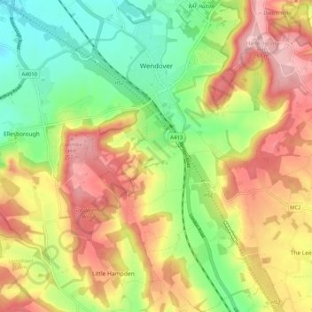
Name: Wendover topographic map, elevation, terrain.

Location: Wendover, Buckinghamshire, England, United Kingdom (51.71840 -0.77513 51.78077 -0.68925)

Average elevation: 587 ft

Minimum elevation: 312 ft

Maximum elevation: 886 ft

Other topographic maps

Click on a map to view its topography, its elevation and its terrain.

Bledlow Ridge

United Kingdom > England > Buckinghamshire

Average elevation: 525 ft

Burcott

United Kingdom > England > Buckinghamshire > Wing

Average elevation: 407 ft

Grove

United Kingdom > England > Buckinghamshire

Average elevation: 308 ft

Loudwater

United Kingdom > England > Buckinghamshire

Average elevation: 299 ft

Tylers Green

United Kingdom > England > Buckinghamshire

Average elevation: 492 ft

Haddington Hill

United Kingdom > England > Buckinghamshire > Halton

Average elevation: 682 ft

Gear up for your next adventure:

🌡️Handheld Weather Meters - Measure wind, temp, and pressure for safe mountain travel
🪶Survival Guide Book - Expert advice for emergency preparedness
🏫Relief Map Kits - Hands-on tools for teaching landforms and elevation
🕶️Glacier Sunglasses - Side shields to protect eyes from high-altitude snow glare
🔊Portable Camp Speaker - Music and alerts at camp

As an Amazon Associate, this site earns from qualifying purchases at no extra cost to you.