
Make a donation
Gear up for your next adventure:
As an Amazon Associate, this site earns from qualifying purchases at no extra cost to you.
Bjelašnica topographic map
Click on the map to display elevation.
Make a donation
Gear up for your next adventure:
As an Amazon Associate, this site earns from qualifying purchases at no extra cost to you.
Bjelašnica
Bjelašnica (Serbian Cyrillic: Бјелашница, pronounced [bjělaːʃnit͡sa]) is a mountain in the Dinaric Alps in central Bosnia and Herzegovina. It is to the southwest of Sarajevo, bordering Mount Igman. Bjelašnica's tallest peak, by which the mountain group got its name, rises to an elevation of 2,067 metres (6,781 ft). Other notable peaks are Krvavac (2,061 m (6,762 ft)), Mali Vlahinja (2,055 m (6,742 ft)), and Hranisava (1,964 m (6,444 ft)). The Bjelašnica range is bordered by the Rakitnica in the south, the Neretva in the west, Mount Igman in the north-east and Mount Ivan in the north-west. Only at 20 minutes distance of Sarajevo, it is a tourist attraction for hiking and skiing.
Make a donation
Gear up for your next adventure:
As an Amazon Associate, this site earns from qualifying purchases at no extra cost to you.
About this map
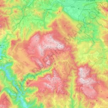
Name: Bjelašnica topographic map, elevation, terrain.
Average elevation: 3,599 ft
Minimum elevation: 951 ft
Maximum elevation: 6,768 ft
Make a donation
Gear up for your next adventure:
As an Amazon Associate, this site earns from qualifying purchases at no extra cost to you.