Geolocate

Gregg topographic map

Click on the map to display elevation.

About this map

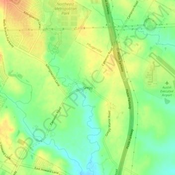
Name: Gregg topographic map, elevation, terrain.

Location: Gregg, Travis County, Texas, United States (30.37550 -97.61043 30.41550 -97.57043)

Average elevation: 614 ft

Minimum elevation: 545 ft

Maximum elevation: 679 ft

Travis County trails, hiking, mountain biking, running and outdoor activities

Gear up for your next adventure:

🧣Hiking Neck Gaiter - Multi‑use neck protection for outdoor weather
🦺Reflective Outdoor Gear - Safety gear for low‑light conditions
🦶Carbon Trekking Poles - Reduce knee impact on steep descents with ultra-light poles
GPS Sports Watch - GPS watch for running, hiking and training
🧭Outdoor Navigation Book - Learn advanced navigation skills

As an Amazon Associate, this site earns from qualifying purchases at no extra cost to you.