
Make a donation
Gear up for your next adventure:
As an Amazon Associate, this site earns from qualifying purchases at no extra cost to you.
La Jumellière topographic map
Click on the map to display elevation.
Make a donation
Gear up for your next adventure:
As an Amazon Associate, this site earns from qualifying purchases at no extra cost to you.
La Jumellière
Sa superficie est de plus de 29 km2 (2 909 ha) et son altitude varie de 20 à 104 mètres.
Make a donation
Gear up for your next adventure:
As an Amazon Associate, this site earns from qualifying purchases at no extra cost to you.
About this map
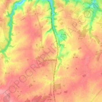
Name: La Jumellière topographic map, elevation, terrain.
Average elevation: 269 ft
Minimum elevation: 62 ft
Maximum elevation: 367 ft
Make a donation
Gear up for your next adventure:
As an Amazon Associate, this site earns from qualifying purchases at no extra cost to you.
Other topographic maps
Click on a map to view its topography, its elevation and its terrain.
La Bordellière
France > Pays de la Loire > Maine-et-Loire > Chemillé-en-Anjou
Average elevation: 502 ft
Make a donation
Gear up for your next adventure:
As an Amazon Associate, this site earns from qualifying purchases at no extra cost to you.
Le Jeu
France > Pays de la Loire > Maine-et-Loire > Chemillé-en-Anjou > Moulin de Grouteau
Average elevation: 328 ft
La Gilardière
France > Pays de la Loire > Maine-et-Loire > Chemillé-en-Anjou
Average elevation: 259 ft
La Chalouserie
France > Pays de la Loire > Maine-et-Loire > Chemillé-en-Anjou
Average elevation: 522 ft
Make a donation
Gear up for your next adventure:
As an Amazon Associate, this site earns from qualifying purchases at no extra cost to you.
Les Fossés Ayrault
France > Pays de la Loire > Maine-et-Loire > Chemillé-en-Anjou
Average elevation: 354 ft
La Hunaudière
France > Pays de la Loire > Maine-et-Loire > Chemillé-en-Anjou
Average elevation: 551 ft
Make a donation
Gear up for your next adventure:
As an Amazon Associate, this site earns from qualifying purchases at no extra cost to you.
La Cheminerie
France > Pays de la Loire > Maine-et-Loire > Chemillé-en-Anjou
Average elevation: 538 ft
Make a donation
Gear up for your next adventure:
As an Amazon Associate, this site earns from qualifying purchases at no extra cost to you.
La Gobardière
France > Pays de la Loire > Maine-et-Loire > Chemillé-en-Anjou
Average elevation: 344 ft
La Haute Garde
France > Pays de la Loire > Maine-et-Loire > Chemillé-en-Anjou
Average elevation: 476 ft
Make a donation
Gear up for your next adventure:
As an Amazon Associate, this site earns from qualifying purchases at no extra cost to you.
L'Aulnay Pichon
France > Pays de la Loire > Maine-et-Loire > Chemillé-en-Anjou
Average elevation: 344 ft
Make a donation
Gear up for your next adventure:
As an Amazon Associate, this site earns from qualifying purchases at no extra cost to you.
La Chapelle
France > Pays de la Loire > Maine-et-Loire > Chemillé-en-Anjou > La Jumellière
Average elevation: 240 ft
Peleau
France > Pays de la Loire > Maine-et-Loire > Chemillé-en-Anjou > Peleau
Average elevation: 276 ft
Make a donation
Gear up for your next adventure:
As an Amazon Associate, this site earns from qualifying purchases at no extra cost to you.
La Grande Touche
France > Pays de la Loire > Maine-et-Loire > Chemillé-en-Anjou
Average elevation: 469 ft
Les Ratelières
France > Pays de la Loire > Maine-et-Loire > Chemillé-en-Anjou > La Jumellière
Average elevation: 279 ft