
Thank you for supporting this site ❤️
Make a donation
Make a donation
Gear up for your next adventure:
As an Amazon Associate, this site earns from qualifying purchases at no extra cost to you.
Brogueira topographic map
Click on the map to display elevation.
Thank you for supporting this site ❤️
Make a donation
Make a donation
Gear up for your next adventure:
As an Amazon Associate, this site earns from qualifying purchases at no extra cost to you.
About this map
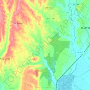
Name: Brogueira topographic map, elevation, terrain.
Location: Brogueira, Torres Novas, Santarém, 2350-052, Portugal (39.39714 -8.59409 39.46083 -8.51944)
Average elevation: 174 ft
Minimum elevation: 33 ft
Maximum elevation: 394 ft
Thank you for supporting this site ❤️
Make a donation
Make a donation
Gear up for your next adventure:
As an Amazon Associate, this site earns from qualifying purchases at no extra cost to you.
Other topographic maps
Click on a map to view its topography, its elevation and its terrain.
Casal do Laranjeiro
Portugal > Santarém > Torres Novas > Casal do Laranjeiro
Average elevation: 358 ft