
Thank you for supporting this site ❤️
Make a donation
Make a donation
Gear up for your next adventure:
As an Amazon Associate, this site earns from qualifying purchases at no extra cost to you.
Bouça dos Homens topographic map
Click on the map to display elevation.
Thank you for supporting this site ❤️
Make a donation
Make a donation
Gear up for your next adventure:
As an Amazon Associate, this site earns from qualifying purchases at no extra cost to you.
About this map
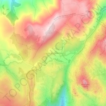
Name: Bouça dos Homens topographic map, elevation, terrain.
Average elevation: 3,579 ft
Minimum elevation: 2,661 ft
Maximum elevation: 4,245 ft
Thank you for supporting this site ❤️
Make a donation
Make a donation
Gear up for your next adventure:
As an Amazon Associate, this site earns from qualifying purchases at no extra cost to you.
Other topographic maps
Click on a map to view its topography, its elevation and its terrain.
Branda de Bosgalinhas
Portugal > Viana do Castelo > Arcos de Valdevez > Gavieira
Average elevation: 3,409 ft