
Thank you for supporting this site ❤️
Make a donation
Make a donation
Gear up for your next adventure:
As an Amazon Associate, this site earns from qualifying purchases at no extra cost to you.
Kut Nok Plao topographic map
Click on the map to display elevation.
Thank you for supporting this site ❤️
Make a donation
Make a donation
Gear up for your next adventure:
As an Amazon Associate, this site earns from qualifying purchases at no extra cost to you.
About this map
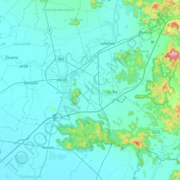
Name: Kut Nok Plao topographic map, elevation, terrain.
Location: Kut Nok Plao, Mueang Saraburi, Saraburi Province, Thailand (14.34690 100.80800 14.66690 101.12800)
Average elevation: 174 ft
Minimum elevation: -26 ft
Maximum elevation: 1,867 ft
Thank you for supporting this site ❤️
Make a donation
Make a donation
Gear up for your next adventure:
As an Amazon Associate, this site earns from qualifying purchases at no extra cost to you.
Other topographic maps
Click on a map to view its topography, its elevation and its terrain.