
Vilvoorde topographic map
Click on the map to display elevation.
About this map
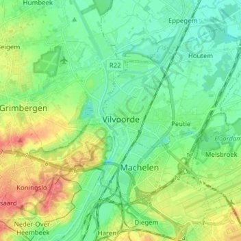
Name: Vilvoorde topographic map, elevation, terrain.
Location: Vilvoorde, Halle-Vilvoorde, Flemish Brabant, Flanders, Belgium (50.89699 4.36046 50.95929 4.48708)
Average elevation: 79 ft
Minimum elevation: 0 ft
Maximum elevation: 246 ft
Other topographic maps
Click on a map to view its topography, its elevation and its terrain.
La Fresnaye
Belgium > Flemish Brabant > Halle-Vilvoorde > Buizingen > Ziekendries
Average elevation: 236 ft
Lac de Genval - Meer van Genval
Belgium > Flemish Brabant > Halle-Vilvoorde > Overijse > Genval
Average elevation: 262 ft