
Thank you for supporting this site ❤️
Make a donation
Make a donation
Gear up for your next adventure:
As an Amazon Associate, this site earns from qualifying purchases at no extra cost to you.
پلام topographic map
Click on the map to display elevation.
Thank you for supporting this site ❤️
Make a donation
Make a donation
Gear up for your next adventure:
As an Amazon Associate, this site earns from qualifying purchases at no extra cost to you.
About this map
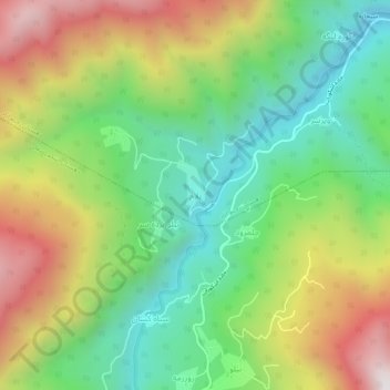
Name: پلام topographic map, elevation, terrain.
Location: پلام, بخش رحیم آباد, Rudsar County, Gilan Province, Iran (36.90090 50.22332 36.94090 50.26332)
Average elevation: 2,267 ft
Minimum elevation: 663 ft
Maximum elevation: 4,665 ft
Thank you for supporting this site ❤️
Make a donation
Make a donation
Gear up for your next adventure:
As an Amazon Associate, this site earns from qualifying purchases at no extra cost to you.