
Make a donation
Gear up for your next adventure:
As an Amazon Associate, this site earns from qualifying purchases at no extra cost to you.
Krugersdorp topographic map
Click on the map to display elevation.
Make a donation
Gear up for your next adventure:
As an Amazon Associate, this site earns from qualifying purchases at no extra cost to you.
About this map
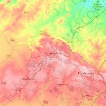
Name: Krugersdorp topographic map, elevation, terrain.
Average elevation: 5,233 ft
Minimum elevation: 4,229 ft
Maximum elevation: 6,014 ft
Make a donation
Gear up for your next adventure:
As an Amazon Associate, this site earns from qualifying purchases at no extra cost to you.
Other topographic maps
Click on a map to view its topography, its elevation and its terrain.
Merafong City Local Municipality
South Africa > Gauteng > West Rand District Municipality
Average elevation: 5,003 ft
Randfontein Local Municipality
South Africa > Gauteng > West Rand District Municipality
Average elevation: 5,305 ft
Coronation Park
South Africa > Gauteng > West Rand District Municipality > Krugersdorp
Average elevation: 5,699 ft
Randfontein Ward 1
South Africa > Gauteng > West Rand District Municipality > Randfontein Local Municipality
Average elevation: 5,236 ft
Make a donation
Gear up for your next adventure:
As an Amazon Associate, this site earns from qualifying purchases at no extra cost to you.
Mogale City Local Municipality
South Africa > Gauteng > West Rand District Municipality
Average elevation: 4,961 ft
Westonaria Local Municipality
South Africa > Gauteng > West Rand District Municipality
Average elevation: 5,131 ft
Merafong City Ward 13
South Africa > Gauteng > West Rand District Municipality > Merafong City Local Municipality
Average elevation: 5,151 ft
Merafong City Local Municipality
South Africa > Gauteng > West Rand District Municipality
Average elevation: 5,003 ft
Make a donation
Gear up for your next adventure:
As an Amazon Associate, this site earns from qualifying purchases at no extra cost to you.
Randfontein Local Municipality
South Africa > Gauteng > West Rand District Municipality
Average elevation: 5,305 ft
Westonaria Local Municipality
South Africa > Gauteng > West Rand District Municipality
Average elevation: 5,131 ft
Mogale City Local Municipality
South Africa > Gauteng > West Rand District Municipality
Average elevation: 4,961 ft
Mogale City Local Municipality
South Africa > Gauteng > West Rand District Municipality
Average elevation: 4,961 ft
Make a donation
Gear up for your next adventure:
As an Amazon Associate, this site earns from qualifying purchases at no extra cost to you.
Mogale City Local Municipality
South Africa > Gauteng > West Rand District Municipality
Average elevation: 4,961 ft
Mogale City Ward 28
South Africa > Gauteng > West Rand District Municipality > Mogale City Local Municipality
Average elevation: 5,381 ft
Randfontein Local Municipality
South Africa > Gauteng > West Rand District Municipality
Average elevation: 5,305 ft